Beijing says the deadly clash began when Indian troops crossed Chinese-controlled territory and tried to dismantle a camp built by Chinese forces in the Galwan Valley at what is known as Patrol Point 14.
At least one analyst, however, cast doubt on what the images showed.
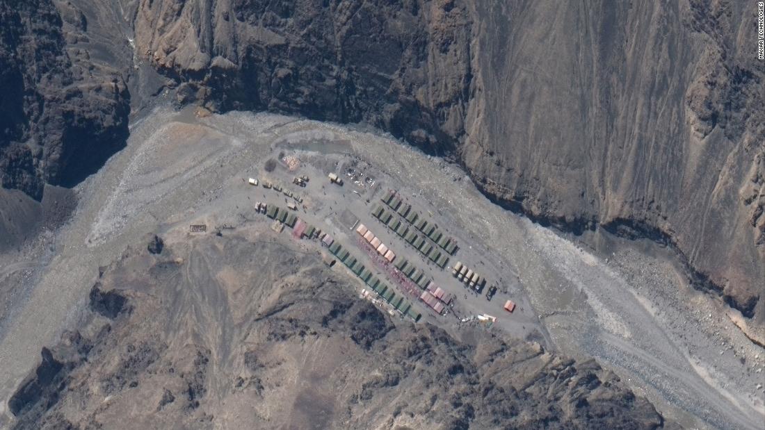
“It seems to me that someone had camped, and it appears to have been a large camp, but they dismantled it,” said Manoj Joshi, distinguished member of the Observer Research Foundation, a New Delhi-based think tank.
Ruser said his analysis of satellite photos showed that since May the number of Chinese troops and vehicles within a kilometer of the border has increased from three to 46, while on the Indian side that number has decreased from 84 to 17.
Tensions continue to rise throughout LAC, despite the agreement between military leaders after the June 15 incident to calm the situation.
China said this week that India was entirely to blame for the clash after Indian troops crossed LAC in violation of a previous agreement.
“It was shocking that Indian troops publicly violated the agreement, broke their own promise and crossed LAC to provoke the Chinese side on June 15,” Wu Qian, a spokesman for the Chinese Defense Ministry, said on Wednesday. “When the Chinese military troops came to negotiate, they were suddenly attacked by the Indian troops, and that led to a physical fight between the two sides and caused casualties.”

India’s foreign ministry responded Thursday, saying China instigated the deadly clash.
“It has been the Chinese actions so far that have led to an increase in tension in the region and also to the violent clash on June 15 with victims,” it said in a statement.
China has been gathering forces in the region for more than a month, the ministry said: “The bottom line is that since the beginning of May, the Chinese side has been accumulating a large contingent of troops and armaments throughout LAC.” .

Maxar’s satellite photos released this week appear to show that China has set up a company of tanks and artillery units in a camp north of Gogra. Another significant base was shown at Kongka Pass.
Ruser, in an analysis published before the latest satellite photos came out, said those earlier photos showed that Chinese troops had been regularly crossing LAC on patrols into Indian territory, though not at the point of the June 15 crash, but that Reports of thousands of Chinese troops camped on Indian soil were not proven.
But he did note that after India began establishing new positions in the Galwan Valley in May, China moved around 1,000 troops to the area.
Joshi said China had changed its tactics in the region, from patrolling disputed areas to occupying them.
“Now the Chinese seem to be indicating that this is where LAC should be. Now it is no longer a place you patrol, but a place you have,” he said.
The valley, part of a region claimed as part of Xinjiang by China and Ladakh by India, is cold and inhospitable, covered in snow with temperatures close to freezing, even in summer. Located high in the Himalayas, the average altitude is 14,000 feet (4,200 meters), almost twice the height at which altitude sickness begins, meaning that any human in the area must undergo tedious and gradual acclimatization or suffer from headaches, nausea and fatigue.
.
