2020/10/19 10:29 Weather news
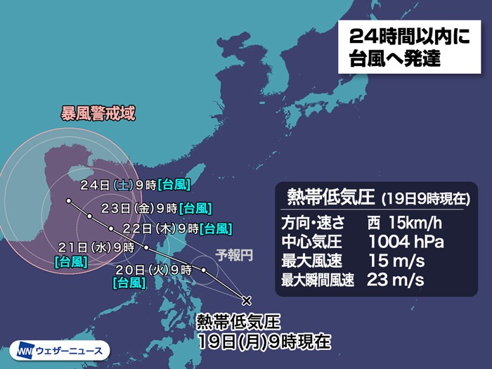
At 9 o’clock on Monday, October 19, tropical low pressure in the eastern part of the Philippines is developing and moving westward. The Meteorological Agency has announced that the tropical low pressure is expected to turn into a typhoon within 24 hours.
After the typhoon, this tropical low pressure is expected to traverse the Philippines, develop the South China Sea, move west and head toward Vietnam. In the surrounding area, caution is required against damage caused by heavy rains, storms, high waves and high tides.
There are no expectations that it will affect the area around Japan.
The next typhoon will be called “Typhoon No. 17”.
![box0]()
▼ Starting at 9:00 am on Monday, October 19
Type of disturbance Tropical low pressure
Area of existence east of the Philippines
Move west 15 km / h
Central pressure 1004 hPa
Maximum wind speed 15 m / s
Maximum instantaneous wind speed 23 m / s
▼ Forecast 24 hours later[10月20日(火)9時]Typhoon Disturbance Type (TS)
Area of existence east of the Philippines
Force class //
Move 20 km / h northwest west
Central pressure 998 hPa
Maximum wind speed 18 m / s (near center)
Maximum instantaneous wind speed 25 m / s

This tropical low pressure is expected to move from the west, but as you can see from the very large forecast circle, there is a high degree of course uncertainty. (* The size of the forecast circle indicates the uncertainty of the course, not the strength or size of the typhoon).
When comparing future positions with simulation results calculated by meteorological organizations around the world, such as Europe and the United States, there are many possible paths for tropical low pressure, from those going west to south Okinawa to those going east south of Honshu. You can see that there is a width. It can be said that the prediction error is very large depending on the strength of the high pressure and the position of the air jet in the sky.
The impact in each area will change a lot depending on the field. Race forecasts get more accurate as the days go by, so be sure to check the latest information from time to time.

Although Typhoon No. 12 is not expected to develop significantly, it may trigger activity from the autumn rain front that is stagnant in southern Honshu, or it may shift to temperate low-pressure nature and approach Honshu.
In the afternoon of the 21 (Monday), the area where the amount of rain is likely to be the greatest is around the Kii peninsula, with heavy rains of more than 300 mm expected in 48 hours until the night of the 24 (Thursday) . Even in the Kanto region, the rain will intensify mainly on the Boso Peninsula, which is close to the front line, and heavy rains of 200mm or more are expected in many places.
Future power and heading will change depending on the relationship to the pressure valley in the sky approaching from the west, so check the latest forecast from time to time. Weather News will continue to monitor the impact and keep you informed.
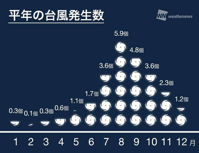
 Typhoon number in normal years
When the next typhoon occurs, it will be called “Typhoon No. 17”, and this is the fourth typhoon to occur this month.
This year, the total number of typhoons that occurred in July was two, which was very small, but there were seven typhoons in August, four in September, and four in October, which is more than normal.
Although the number of typhoons that occur in October decreases every year, we cannot be vigilant because even in the last half of October, we can approach the Honshu area with great force. Recheck preparations for heavy rains and storms caused by typhoons.

Regarding the names of typhoons, 140 names proposed by the member countries of the international organization “Typhoon Committee” are prepared in advance and given in the order of appearance.
Typhoon No. 13’s name “Kujira” is a name proposed by Japan and is taken from the constellation “Kujira”.
