2020/10/08 22:28 Weather news
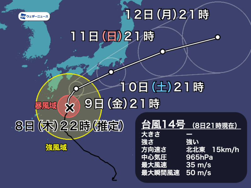
At 9:00 p.m. on Thursday, October 8, Typhoon No. 14 (Chang Hong), which is a powerful force, is moving north over the sea east-southeast of Kyushu. Some parts of Kagoshima prefecture, Miyazaki prefecture, Kochi prefecture, etc. They are in the region of strong winds with a wind speed of 15 m / s or more.
The typhoon will move from north to south of Shikoku, and as of tomorrow 9 (Friday), the course will gradually change to the east, and there is a risk that it will come considerably closer to the main island. Consider future information.
▼ Typhoon No. 14 Thursday October 8 9:00 p.m.
Area of existence Approximately 260 km east-southeast of Taneshima
Size class //
Strong force class
Move north-northeast 15 km / h
Central pressure 965 hPa
Maximum wind speed 35 m / s (near center)
Maximum instantaneous wind speed 50 m / s
![box0]()
With the typhoon approaching, the wind is gradually increasing in western Japan. At Amedas Onoma, which is located in Yakushima, Kagoshima prefecture, a strong wind was observed with an instantaneous maximum speed of 36.0 m / s at 12:03. At 10:55 a.m., the maximum instantaneous wind speed of 30.8 m / s was observed at Cape Muroto in Kochi prefecture.
Stay away from the coast as it is stormy and dangerous in coastal areas.

Typhoon No. 14 is expected to move north off Shikoku without increasing its speed. After that, as you change course to the northeast, you can advance from the Kii Peninsula to the Tokai coast, and from Saturday the 10th to Sunday the 11th morning, you can approach or land in eastern Japan.
If the center of the typhoon approaches, both the rain and the wind will intensify and the weather will be harsh, so caution is required.
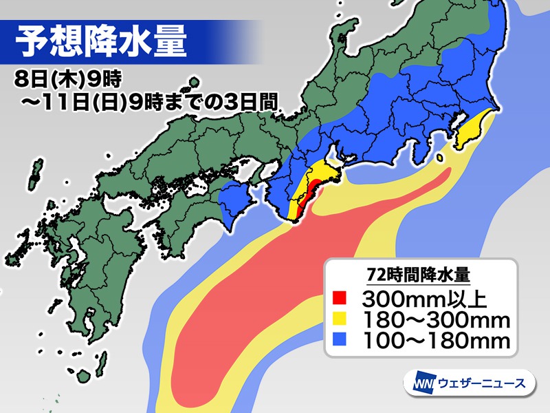
 Forecast of total rainfall until 9:00 am on Sunday 11
It has been raining due to the influence of the autumn rain front before the arrival of the typhoon, and there is a risk of heavy rain on the Pacific side of eastern Japan and Kinki. In particular, heavy rains are expected due to the influence of the topography in the southern part of the Kii peninsula and the formation of a small front called the coastline on the Boso peninsula.
According to the Weather News forecast as of 8 (Thursday), total precipitation for 3 days (72 hours) to 9 o’clock on the 11 (Sunday) may exceed 300mm in the southern part of the Kii Peninsula and the 200mm in Kanto and other areas like Chiba prefecture. I think it can rain up to 300mm.
In addition to this, if the course of the typhoon moves north, it is undeniable that the typhoon itself will be exposed to active rain clouds, and the total precipitation will be close to 500 mm in the southern part of the Kii Peninsula, the Izu islands and the Boso peninsula. Beware of sediment-related disasters and river flooding.


As the typhoon gradually begins to lose strength off the coast of Shikoku, the storm areas are believed to be mainly in the southern part of the Kii Peninsula, the Izu Peninsula, the Izu Islands and the Boso Peninsula. .
However, if the course of the typhoon moves northward, the area entering the typhoon storm area will increase, and there is a risk that a storm of 30 m / s or more will blow momentarily even in urban areas. Beware of power outages.

Due to the weak winds in the sky and the difficulty of predicting the high pressure forces that govern the course, it is difficult to accurately predict whether a typhoon will approach or leave the ground. Even a small difference in course can make a big difference in effect.
Depending on the conversion situation tomorrow 9 (Friday), the forecast for the subsequent course is expected to be more accurate, so please continue to check the latest forecast.

As for the names of typhoons, 140 names proposed by the member countries of the international organization “Typhoon Committee” are prepared in advance and given in the order of appearance.
Typhoon # 14’s name “Chan-hom” is a name proposed by Laos and is derived from the name of the tree.


