2020/10/07 05:52 Weather news
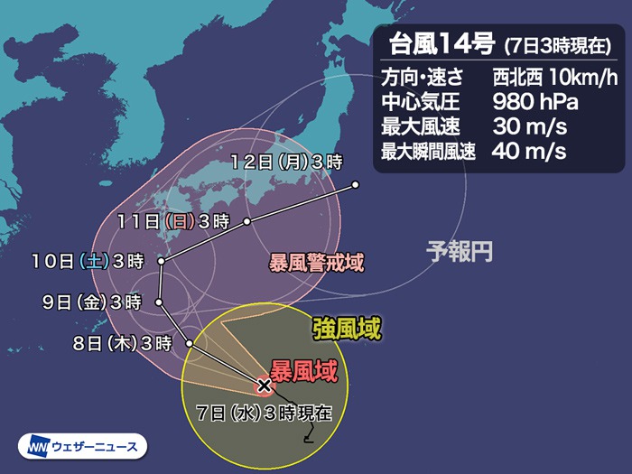
At 3 o’clock on Wednesday the 7th, Typhoon No. 14 (Chang Hong) is heading west-northwest over the sea south of Japan. It has developed a bit and a storm area has been created with a wind speed of 25 m / s or more.
Subsequently, to move north into the typhoon-friendly environment zone, it is expected to approach the Amami region and the Pacific side of western Japan while gradually strengthening its power.
▼ Typhoon No. 14 Wednesday, October 7, 3:00
Area of existence South of Japan
Move 10 km / h northwest west
Central pressure 980 hPa
Maximum wind speed 30 m / s (near center)
Maximum instantaneous wind speed 40 m / s
![box0]()
The typhoon is expected to develop to the northwest over the weekend, approaching Amami and Kyushu, and then east on the southern coast of the Japanese archipelago. When turning east, the speed is expected to be significantly slower, which can have a prolonged effect.
However, the forecast circle is very large after Saturday the 10th, and even the forecast circle at 3:00 on Sunday the 11th covers from Kyushu to Kanto.
At this stage, the range of heading and speed forecasts is very wide and difficult to narrow down precisely. (* The size of the forecast circle does not indicate the strength or size of the typhoon, but the uncertainty of the course.)
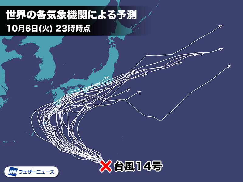
 (Reference) Forecasts around the world
When comparing future positions with simulation results calculated by meteorological agencies around the world, such as Europe and the United States, most of them have moved to the northwest and then to the east. However, there are still large differences in the timing and location of when and where to change course to the east. There is still a wide range of forecasts, which is a factor in increasing the forecast circle.
It is still difficult to determine whether to pass close to the ground and when to approach. The course will change depending on the strength of the high pressure, the position of the jet airflow, the timing of the pressure valley in the oncoming sky, etc., so check the latest information at any time.
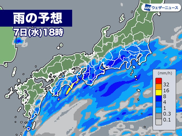
 Predicted Rain 7 (Wed) 18:00
The fall rain front is moving north before the typhoon hits, and it will start raining this afternoon on the early part of the Pacific Ocean side. From late to night, it is expected to rain over a wide area on the Pacific side west of Kanto.
Due to the slow movement of typhoons, it is easy for it to rain from the weekends to the beginning of the week. If the typhoon travels near the Japanese archipelago, it can cause heavy rain, so be careful with future information.

Typhoon No. 14 is the first typhoon to occur in October this year. The average number of typhoons in October is 3.6.
This year, the total number of typhoons that occurred in July was very small, at 2, but there were 7 typhoons in August and 4 typhoons in September.
Although the number of typhoons starts to decrease in October of each year, we cannot be vigilant because we can approach the Honshu area with strong force. Recheck preparations for heavy rains and storms caused by typhoons.

Regarding the names of typhoons, 140 names proposed by the member countries of the international organization “Typhoon Committee” are prepared in advance and given in the order of appearance.
Typhoon # 14’s name “Chan-hom” is a name proposed by Laos and is derived from the name of the tree.
Visible image of the meteorological satellite: ICT Information and Communication Research Organization
