[ad_1]

2020/09/06 09:53 Weather news
Amami Oshima and other areas entered the storm zone, and the maximum instantaneous wind speed of 38.6 m / s was observed at 9:33 a.m. at Kikaijima. In the city of Miyazaki, where a very active band of rain clouds called the “outer band” passes outside the typhoon, it rained a lot of 51.5 mm in an hour until 9:30.
Due to the approaching typhoon, a large-scale disaster may strike tomorrow Monday the 7th that has not been seen in recent years. You cannot evacuate after the storm starts, so feel free to evacuate before approaching.
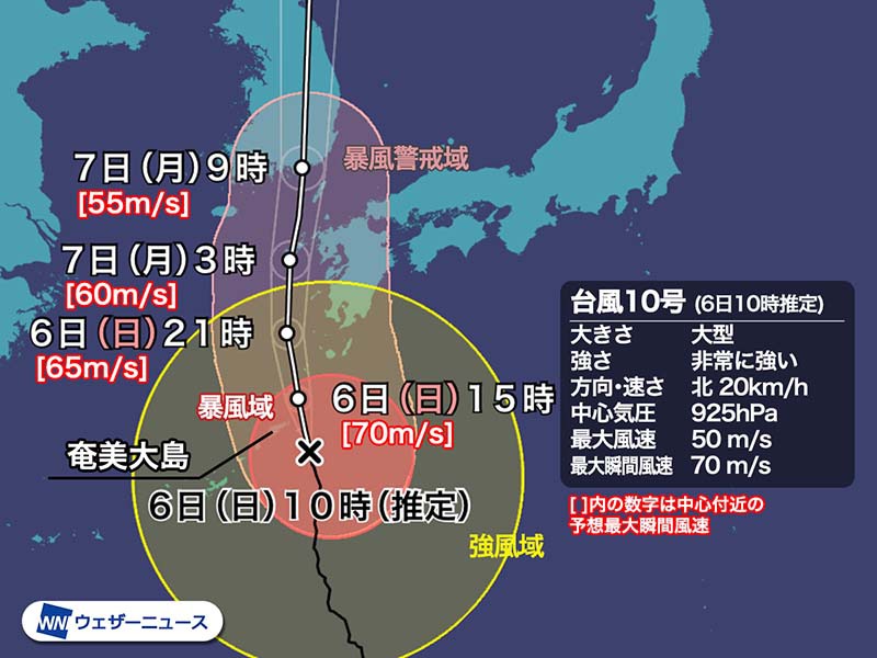
▼ Typhoon No. 10 Estimated at 10:00 on Sunday, September 6
Existence area Approximately 110 km southeast of Amami Oshima
Large size class
Very strong force class
Move north 20 km / h
Central pressure 925 hPa
Maximum wind speed 50 m / s (near center)
Maximum instantaneous wind speed 70 m / s

A large area of the Amami region has already entered a storm area with a wind speed of 25 m / s or more. In the future, it is expected to enter the storm zone around noon in Taneshima and Yakushima in Kagoshima prefecture, in the afternoon in Kagoshima, and late at night in Nagasaki.
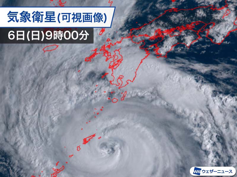
In the satellite image, you can see that extremely developed rain clouds near the center of the typhoon are approaching Amami Oshima, and the “outer band” is over Kyushu.
Record storms, high tides, and heavy rain, especially in Kyushu, can cause catastrophic disasters. When evacuating, please complete it before entering the stormy area and making movement difficult.

Countless damages are forecast, such as house collapses and car rollovers, large-scale power outages due to collapse of power poles and steel towers, traffic paralysis due to sediment disasters caused by downed trees and heavy rain, disasters of sediments caused by torrential rains and departure from port facilities due to waves and high tides. It will be done.
In preparation for any disaster, first consider protecting your safety and staying in a safe place until the typhoon passes.
Typhoon No. 10’s name “Haishen” is a name proposed by China and literally means god of the sea.


